Powerpoint
Presentation
![]()
Associated Press.
438 Words
3157 Characters
08/08/98
Chicago Tribune
ĪĪ
Divers searched for two missing boys Friday as drenching rains
eased, leaving emergency workers and property owners with a big
cleanup. The rains had sent floodwaters rushing over roads,
buildings and railroad tracks.
The boys, ages 12 and 14, disappeared Thursday near a water-filled
culvert in suburban Elm Grove. Divers found no sign of them Friday
before suspending their search until the water in a nearby stream
recedes.
No other serious injuries were reported from the deluge that left
an Amtrak train stalled overnight just west of Milwaukee and caused
some buildings to collapse 50 miles to the north in Sheboygan.
* Gov. Tommy Thompson, who declared a state of emergency for flood-
stricken counties, toured the Sheboygan area Friday as officials
started assessing the extent of damage.
Although the water was receding Friday, The Mill Place shopping
center in Elm Grove was still swamped in about five feet of water as
business owners returned to check the damage.
Amid the sound of pumps vacuuming brown water from the flooded
parking lot, Kevin Benkowski donned a pair of chest-high waders to
enter his store, Just Kidding, and film the wreckage for his
insurance agent and his lawyer.
"It's a total loss," he said of the store, which sells children's
clothing. "Everything's floating."
The shopping center is on the banks of Underwood Creek, which
quickly overflowed Thursday as about eight inches of rain poured
down. Water in Benkowski's store reached seven feet Thursday, and he
and his wife had to be pulled out through windows by rescuers.
Employees of Reinders Inc., on the other side of the creek, were
* cleaning up debris that washed into the parking lot during the flood.
* "The cleanup in a flood is a major task," said Richard Reinders,
president of the golf course-equipment firm. "You can clean and
clean, and you'll never get it done."
In Sheboygan, homeowners who were evacuated Thursday began
returning to flooded basements and swamped yards.
Inspectors found structural damage in some homes, and those
residents were not allowed to return Friday, said Deputy Police Chief
David Kirk.
Police and private security officers were patrolling in the area
of abandoned dwellings to prevent looting, Kirk said. State prison
inmates were being brought in to help with the cleanup.
An Amtrak train that became stuck on waterlogged crossing in
suburban Wauwatosa on Thursday was finally moved about 6:30 a.m.
Friday. The Empire Builder's 350 passengers headed to the West Coast
from Chicago were given alternative transportation Thursday, an
Amtrak spokesman said.
Forecasters attributed the intense downpours on a slow-moving low
pressure system that caused moisture-laden air to rise and produce
the cloudbursts.
Click
On Me to Go Back To The main Page
CHINA PLANS TO OPEN YANGTZE FLOODGATES
Associated Press.
391 Words
3048 Characters
08/08/98
Chicago Tribune
Carrying what possessions they could, hundreds of thousands of
Chinese villagers Friday turned their backs on homes that will be
sacrificed to the raging waters of the Yangtze River if authorities
resort to drastic measures to keep flooding at bay.
With the river at record levels and rising, officials were
preparing to open floodgates and, if that failed, blow up a dike to
divert the swollen waters from one of the most threatened sections of
the 3,900-mile waterway.
Local authorities said late Friday they had not received the order
* to inundate the Jingjiang flood plain, a 47-mile area dotted by a
half-dozen hamlets and a city of 500,000 people. The move would
require the approval of China's State Council, or Cabinet.
A fresh surge of water down the river Friday raised new fears
among officials that sodden levees weakened by more than a month of
rain and floods would give way.
More than 2,000 people have died in summer floods that began in
June, and the death toll continued to rise as new reports come in
from inundated areas.
By late Friday, some 250,000 of the 330,000 residents ordered to
vacate the Jingjiang plain had been evacuated to higher ground, the
official New China news agency reported. Those who lost their homes
in the diversion would be compensated by the government, it said.
Local authorities declared an around-the-clock curfew in Gong'an
County, which would bear the brunt of a deliberate flooding.
If the order were given, officials first would raise floodgates to
deflect water from the Yangtze's banks and reduce the torrent rushing
downstream. If that proved insufficient, a nearly two-mile-long dike
that borders the river would be dynamited to let the floodwaters
* through, said Chen Zhichao, director of the Jingjiang Flood Diversion
Management Bureau.
Embankments protecting Jiujiang city, down river in southeast
Jiangxi province, partly collapsed Friday, swamping parts of the city
to a depth of nearly seven feet, the news agency said.
Emergency workers sank three boats in an effort to plug the 132-
foot-wide gap and struggled to build a second emergency dike for the
city, a petrochemical and textile center on China's main north-south
railway line, it said.
Officials also were breaking open or deliberately abandoning
smaller, secondary dikes to lower the Yangtze, flooding farmland and
taking pressure off the major embankments that hem in the river.
Click
On Me to Go Back To The main Page
Rains Produces Wisconsin Flooding
JIM CHILSEN
464 Words
3082 Characters
08/07/98
AP Online
Associated Press
ĪĪ
MILWAUKEE (AP) - Bloated by days of rain, urban creeks and sewers
unleashed their fury during afternoon rush hour, gushing coffee-
colored water into basements and driving hundreds of people from
their homes.
A third consecutive rainy day set the stage for misery Thursday,
when rain amounts of 5 and 6 inches were commonplace across southern
Wisconsin.
With nowhere else to go, water spilled out of urban creeks and
overloaded sewers, closing streets and freeways as workday commuters
were heading home. In Sheboygan, rescuers pulled a dentist to safety
moments before his house slid into a ravine.
In hard-hit suburban Elm Grove, rescue crews searched late
Thursday for two boys, 12 and 14, reported to have been swept away as
they played in a drainage ditch.
The search was called off early today and it wasn't clear when it
would resume, said a police dispatcher who said rescuers had not
found the boys.
The Menomonee River climbed to 17.8 feet at Milwaukee, nearly
* double its flood stage.
"It has been coming into the basement. We have two sump pumps
running, and we know the hardest part is going to be starting (today)
with the cleanup," said Betty Rooney of Milwaukee.
The cleanup may be a long time coming, with more rain in the
weekend forecast.
Rooney said her back yard was under 22 inches of water, flowing
over a slope like a "small Niagara Falls."
About 300 people were evacuated from homes in Milwaukee, Wauwatosa
and Brown Deer. Some went to Red Cross shelters, others to
relatives' homes.
Some compared the latest flooding to what was supposed to have
* been a once-in-a-lifetime flood on June 21, 1997.
"A year and a month ago we had the same conversation," resident
Ron Peter said, resigning himself to water in his basement. "It's
only 4 inches but I'm sure more's to come."
Traffic on Interstate 94 was halted near suburban Brookfield,
which recorded 8.5 inches of rain within a few hours Thursday.
About a foot of rain fell on Sheboygan, a Lake Michigan city of
50,000. The floodwaters tore chunks of asphalt from city streets and
forced apartment-house evacuations.
At one point, as many as 3,000 customers were without electricity
in the Milwaukee metro area. Water closed Milwaukee's Timmerman
Airport and swamped roads.
Water on some streets was 6 feet deep with divers and firefighters
checking submerged vehicles for occupants, the National Weather
Service said.
At one place on the freeway, "the boats were going over the cars,"
said Marchewka.
He said the Menomonee was rising by the foot early Thursday
afternoon. "It was absolutely noticeable, and that's when all hell
broke loose."
The threat remains with more rain forecast, said weather service
meteorologist Jason Puma.
"Essentially all of southern Wisconsin is still in danger," he
said.
Click
On Me to Go Back To The main Page
* Ind. town has worst flood in 40 years
Cathy Kightlinger
Chronicle-Tribune
261 Words
1979 Characters
08/06/98
USA Today
ĪĪ
MARION, Ind. -- After nearly 8 inches of rain and a bulging river
levee sent panicked families from their homes, there was only one
thing to do Wednesday.
Wait.
* Marion's worst flood in 40 years prompted city officials to
declare a state of emergency, call in the National Guard and
evacuate flooding neighborhoods.
By midday, the mess brought businesses and government in this
city of 33,000 to a halt. The severity of record-setting rainfall
and its devastating effect rested on whether the levee would hold
* back flood waters.
Though it came within inches of bursting and was weakened by a
gaping foot-wide hole, sandbags shored up the levee late Wednesday.
And after cresting about 5 p.m., the water level had receded half
a foot by Wednesday night and the levee held, Marion Police chief
* Dave Homer said. Nevertheless, flash-flood warnings remained in
effect through dawn.
Every Wednesday, the Mississinewa River was rising 5 inches an
hour. The National Weather Service reported that 7.67 inches of
rain had fallen in the 31-hour period from midnight Tuesday to 7
1.m. Wednesday.
About 6 inches of that came from 2 p.m. to 8 p.m. Tuesday.
About 40 families in Johnstown, on Marion's east side, were
evacuated.
The area's middle schools were prepared to take on families forced
from their homes, but most found shelter with friends and relatives.
In the wake of the rainfall, an army of volunteers, including 50
National Guard troops, helped fill sandbags at the city's National
Guard Armory.
City workers fanned out across Marion, directing traffic and
checking on residents.
Click
On Me to Go Back To The main Page
SEOUL, South Korea (AP) �
Torrential rains triggered floods
SANG-HUN CHOE
354 Words
2508 Characters
08/05/98
AP Online
Associated Press
SEOUL, South Korea (AP) - Torrential rains triggered floods and
landslides in Seoul and surrounding provinces Thursday, killing at
least 11 people and submerging thousands of homes.
Disaster relief headquarters urged 200,000 people in low-lying
districts of the capital to evacuate as tributaries to the Han River
bisecting the city threatened to overflow.
TD Suburbs north and west of Seoul were submerged in waist-deep
water. Rescuers used rubber boats to help move citizens to higher
ground. A satellite city north of Seoul was completely cut off, with
roads swept away, a subway line flooded and telephone poles downed.
* Four people were killed when a flash flood engulfed homes along a
valley in Uijongbu north of Seoul. A 49-year-old woman was
electrocuted in a nearby city. A 56-year-old woman was killed in a
landslide.
Five people were missing after a restaurant in an amusement park
north of Seoul collapsed under a landslide. Six others were injured.
Up to 24 inches of rain poured down in Seoul and its suburbs
between late Wednesday and Thursday morning, submerging 5,800 homes
and other buildings and leaving at least 3,000 people homeless.
With weather forecasters predicting more rains, long lines of
people trekked along railway lines to higher ground. Large stretches
* of green rice fields disappeared under brown flood water.
In Seoul, subway service was disrupted during busy commuting hours
when water submerged tracks.
President Kim Dae-jung ordered the military to dispatch soldiers
and equipment to step up relief efforts.
A front spreading east from China has been dumping rain on South
Korea since last weekend, first in the south and then in the north.
Flash floods turned streams and ravines in a national park in the
southern part of the nation into raging torrents over the weekend,
leaving 62 people dead and 32 missing.
On Wednesday night, a Korean Air passenger plane skidded off a
rain-slicked runway while landing at Seoul's Kimpo International
Airport, injuring 22 people.
The flight, carrying 397 passengers from Tokyo's Narita airport,
bounced and skidded before coming to a halt in a meadow.
Six of those injured were Japanese and the rest were South Korean.
Click
On Me to Go Back To The main Page
* Earthquakes hit Ecuador
32 Words
687 Characters
08/06/98
Financial Times
USA Edition
ĪĪ
* Earthquakes hit Ecuador
Military planes were flying food and supplies to hundreds of victims
* left homeless by two strong earthquakes on Ecuador's Pacific coast which
toppled buildings and killed three people.
ĪĪ
Click
On Me to Go Back To The main Page
* Two Earthquakes Strand Hundreds, Kill Three In Ecuador
181 Words
1580 Characters
08/05/98
11:27
Dow Jones News Service
ĪĪ
QUITO, Ecuador (AP)--Military planes on Wednesday began flying food
and clothing to hundreds of refugees on Ecuador's Pacific coast after
* two strong earthquakes toppled buildings, killing three people.
President Fabian Alarcon declared the coastal province of Manabi where
the quakes hit on "yellow alert," which required rescue workers to
prepare safe areas in schools and hospitals in case of further tremors.
The twin quakes struck Tuesday afternoon near the resort town of Bahia
de Caraquez, 220 kilometers southwest of Quito, causing 200 houses and
buildings to collapse, civil defense officials and police reported.
The quake was also felt in Quito where office towers swayed and
workers ran out to the streets.
The first quake struck with a magnitude of 5.7, according to Ecuador's
Geophysical Institute.
The second struck more than an hour later with a magnitude of 7.1, the
U.S. Geological Survey in Golden, Colo. reported.
At least 30 tremors followed the two quakes.
The earthquake was the largest in the area since a 7.8 magnitude
earthquake on Jan. 19, 1958, the institute said.
Click
On Me to Go Back To The main Page
Three Die in Ecuador Earthquake
GONZALO SOLANO
415 Words
2799 Characters
08/05/98
AP Online
Associated Press
ĪĪ
QUITO, Ecuador (AP) - Military planes began flying food and
clothing to hundreds of refugees on Ecuador's Pacific coast Wednesday
* after two strong earthquakes toppled buildings, killing three people.
President Fabian Alarcon ordered rescue workers in the coastal
province of Manabi to prepare safe areas in schools and hospitals in
case of further tremors.
TD The twin quakes struck Tuesday afternoon near the resort town of
Bahia de Caraquez, 130 miles southwest of Quito, causing 200 houses
and buildings to collapse, civil defense officials and police
reported.
Fearing further tremors, hundreds of residents of towns in Manabi
spent the night on soccer fields or in parks, many sleeping under
tarpaulins fashioned into shelters.
Workers began clearing rubble and bricks from the streets of Bahia
de Caraquez, a port city with population 20,000 and prime vacation
spot for the wealthy set in this small Andean nation.
The quakes left cracks in several of a string of highrise
apartments that ring the tropical beach front, but none collapsed.
One woman died of a heart attack during the panic, and a young
girl and a woman were killed by falling walls when their houses
collapsed in different towns in Manabi, a police report said, raising
the death toll to three.
Local hospitals reported treating 20 injured people.
A rumor swept Bahia de Caraquez that a tsunami caused by the
quakes was coming, causing dozens of residents to flee to higher
ground. The tsunami never came, but some people waited overnight on
nearby hills.
When the quake hit, the impoverished region was still recovering
from massive flooding driven by the El Nino weather phenomenon
earlier this year. The flooding wiped out much of the area's
infrastructure.
"I lost my house to El Nino, so I moved to a new neighborhood.
Now I have lost another house to an earthquake," said a sobbing Lidia
Cespedes, standing amid the ruins of her small house in Bahia de
Caraquez.
Television footage showed President Alarcon on Tuesday holding a
table and looking nervous as a quake shook the governor's palace in
Guayaquil, Ecuador's largest city, where he was attending a state
function.
The quake was also felt in Quito, 130 miles away, where office
towers swayed and workers ran out to the streets.
The first quake had a magnitude of 5.7, according to Ecuador's
Geophysical Institute. The second struck more than an hour later and
measured 7.1, the U.S. Geological Survey in Golden, Colo., reported.
At least 30 smaller tremors followed the two quakes.
Click
On Me to Go Back To The main Page
Third Moderate Quake in 6 Days Hits Mammoth Area
98 Words
1000 Characters
08/06/98
Los Angeles Times
ĪĪ
A magnitude 4.1 earthquake struck the Eastern Sierra resort area of
Mammoth Lakes on Wednesday, the third moderate temblor there in the last
six days, the U.S. Geological Survey reported.
The 6:44 a.m. jolt was centered 11 miles southeast of Mammoth Lakes in
close proximity to other quakes in a series that began June 8. The
strongest of the quakes have been magnitude 5.1 temblors June 8 and July
14.
No damage was caused by Wednesday's quake. The Geological Survey said
about 70 smaller quakes also occurred nearby in the 24-hour period of
Tuesday afternoon and Wednesday morning.
Click
On Me to Go Back To The main Page
Third Moderate Quake in 6 Days Hits Mammoth Area
98 Words
1000 Characters
08/06/98
Los Angeles Times
ĪĪ
A magnitude 4.1 earthquake struck the Eastern Sierra resort area of
Mammoth Lakes on Wednesday, the third moderate temblor there in the last
six days, the U.S. Geological Survey reported.
The 6:44 a.m. jolt was centered 11 miles southeast of Mammoth Lakes in
close proximity to other quakes in a series that began June 8. The
strongest of the quakes have been magnitude 5.1 temblors June 8 and July
14. No damage was caused by Wednesday's quake. The Geological Survey said
about 70 smaller quakes also occurred nearby in the 24-hour period of
Tuesday afternoon and Wednesday morning.
Click
On Me to Go Back To The main Page


Click
On Me to Go Back To The main Page
 Earthquake
and Shock Waves
Earthquake
and Shock Waves
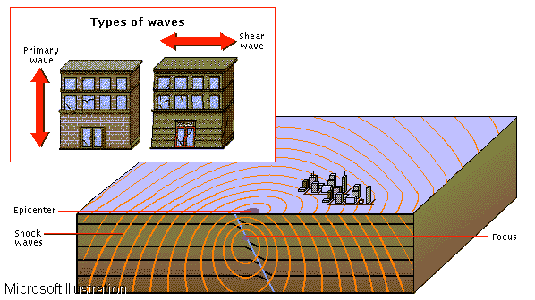
Earthquakes occur when a build-up of pressure or strain between sections of rocks within the earth�s crust is suddenly released, causing minor or severe vibrations on the surface of the land. The point at which layers of rock shift and reposition in relation to one another is called the focus; this is the effective center of the earthquake. Directly above the focus, a second point called the epicenter marks the corresponding point of highest-intensity shock on the surface. Shock waves propagate like ripples from the focus and epicenter, decreasing in intensity as they travel outward. The main types of seismic waves are primary waves (P waves) and shear waves (S waves). P waves cause particles to vibrate in the same direction as the shock wave (left). P waves are the first to be recorded in an earthquake because they move faster than S waves (right), which cause vibrations perpendicular to the direction of travel.
Click
On Me to Go Back To The main Page
 Earthquake
Destruction
Earthquake
Destruction
In September 1985 a devastating earthquake shook Mexico City, Mexico, causing severe damage and destroying many of the city�s buildings. The quake left almost 30,000 people homeless and 7000 dead.
Click
On Me to Go Back To The main Page
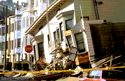 Loma
Prieta Earthquake
Loma
Prieta Earthquake
Centered south of San Francisco, the October 1989 Loma Prieta earthquake measured 7.1 on the Richter scale. The quake shook the entire San Francisco Bay Area, causing extensive damage to older buildings in the Marina District, shown here. The quake also caused the collapse of a highway in Oakland and part of the San Francisco-Oakland Bay Bridge.
Click
On Me to Go Back To The main Page
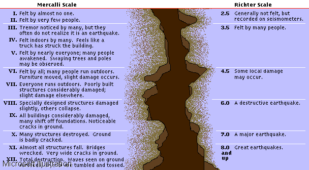 Earthquake
Scales: Mercalli and Richter
Earthquake
Scales: Mercalli and Richter
The Richter and Mercalli scales are used to rate and compare the intensity of earthquakes. Richter�s scale measures the energy of a quake at its center, or focus, and the rating intensity increases exponentially from one number to the next. Mercalli�s scale is more subjective, because the apparent intensity of an earthquake depends on how far away from its center the observer is standing. Running from I to XII, it describes and rates earthquakes more in terms of human reactions and observations than the mathematically based Richter scale.
Click
On Me to Go Back To The main Page
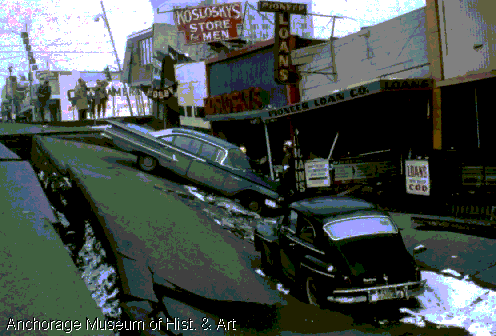 Alaskan
Earthquake
Alaskan
Earthquake
The Alaskan earthquake of 1964 was rated 9.2 on the Richter scale. One of the most powerful earthquakes ever known to hit North America, it claimed 131 lives and devastated parts of Anchorage and Valdez. The quake liquefied foundations and left gaping cracks in the cement of this street.
Click
On Me to Go Back To The main Page

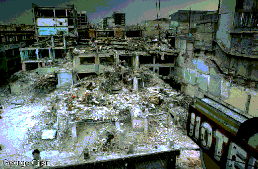
In January 1995 an expressway connecting K?be with ?saka collapsed during the most deadly earthquake to hit Japan since 1923. The quake ignited firestorms and caused massive destruction in K?be. In all, more than 5000 people were killed and hundreds of thousands were left homeless.
Click
On Me to Go Back To The main Page

A severe thunderstorm near Las Vegas, Nevada, caused this flash flood across Interstate 15. Flash floods often occur in mountainous regions where water rushes rapidly downhill or in desert regions where storm water may exceed the infiltration capacity of the ground.
Click
On Me to Go Back To The main Page

Jacksonport, Arkansas, is inundated by flood waters of the White River. River flood hazards often increase in the spring when increased rainfall and snow-melt add to the total water runoff.
Click
On Me to Go Back To The main Page

The Kariba Dam lies along the border between Zambia and Zimbabwe. The facility controls flooding and supplies hydroelectric power to both countries. A public road traces the rim of the dam, between reservoir Lake Kariba and the drop to the Zambezi River. The distinct arch shape distributes pressure evenly on the overall structure of the dam.
Click
On Me to Go Back To The main Page

Due to climate, drought, poor agricultural planning, political instability, and ineffectiveness and the mismanagement of natural resources, there are millions of starving people throughout the world. It is estimated that each year between 5 and 20 million people die of starvation; many of them, like those in the photo, are children.
Click
On Me to Go Back To The main Page
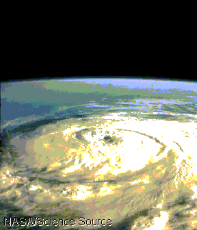 Hurricane
Elena
Hurricane
Elena
On September 2, 1985, Hurricane Elena was photographed with a 70 mm lens from the space shuttle Discovery. Because the hurricane is in the northern hemisphere, the air circles in a counterclockwise motion toward the low pressure center, or eye.
Click
On Me to Go Back To The main Page
ĪĪ
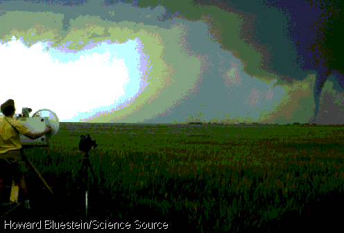 Tornado
Watching
Tornado
Watching
A meteorologist tracks a tornado as part of ongoing weather observations to better understand the earth�s atmosphere. Since the 19th century, scientific forecasting has greatly improved. Weather radar can detect and track tornados, hurricanes, and other severe storms.
Click
On Me to Go Back To The main Page
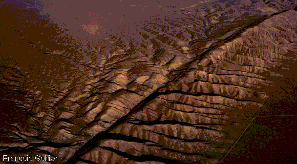 San
Andreas Fault, California
San
Andreas Fault, California
The San Andreas Fault, unlike most faults that stay below the ocean, emerges from the Pacific Ocean and traverses hundreds of miles of land. It runs through California for about 1000 km (about 600 mi) from Point Arena to the Imperial Valley. The fault marks the boundary between the North American and Pacific tectonic plates; earthquakes are caused by these plates sliding together.
Click
On Me to Go Back To The main Page
 Volcanic
Eruption
Volcanic
Eruption
The 1983 eruption of Kilauea crater spilled molten, basaltic lava down the flanks of Mauna Loa volcano on Hawaii Island, Hawaii. Hawaiian volcanos are examples of broad shield volcanos that form from lava eruptions. Composite volcanos form when lava eruptions alternate with violent ash eruptions.
Click
On Me to Go Back To The main Page
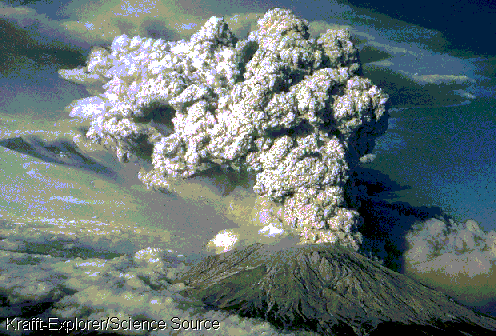 Eruption
of Mount Saint Helens
Eruption
of Mount Saint Helens
The volcano known as Mount Saint Helens, in the southwestern portion of the state of Washington, in the United States, began to erupt on March 27, 1980, after a long period of dormancy. It continued to burble until its first large-scale eruption May 18, 1980. This violent blast sent clouds of ash and other volcanic debris into the atmosphere and killed at least 60 people. With the eruption the mountain�s elevation dropped from 2950 m (9677 ft) to 2549 m (8364 ft).
Click
On Me to Go Back To The main Page
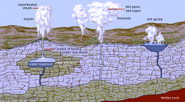 Formation
of Geysers
Formation
of Geysers
Geysers are caused when underground chambers of water are heated to the boiling point by volcanic rock. When heat causes the water to boil, pressure forces a superheated column of steam and water to the surface. The initial amount of water released at the surface lessens the column�s weight, which also lowers its boiling point. When the boiling point drops, the entire column of water vaporizes at once, shooting out of the ground in a spectacular eruption. Fumaroles are similar to geysers, but release bursts of hot gases instead of water. Hot springs are supplied by the same sources as geysers, but these systems are under lower pressure, which causes water to bubble and pool at the surface instead of erupting. The water in these naturally heated springs often exceeds temperatures of 60� C (140� F).
Click
On Me to Go Back To The main Page
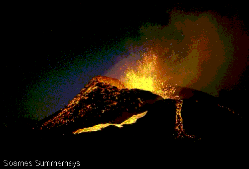
 New
Lava
New
Lava
Red-hot lava flows from a volcano on Rķunion, an island off the coast of Africa in the Indian Ocean. The lava wrinkles because the exterior and interior of the flow cool at different rates. The surface of the flow cools relatively quickly, forming a skin that becomes deformed as the hotter lava moves underneath.
Click
On Me to Go Back To The main Page
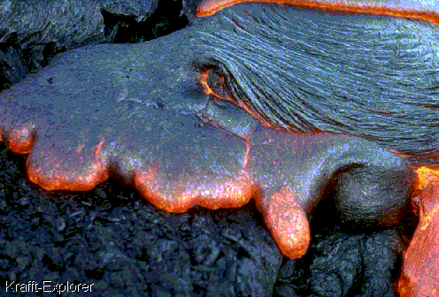
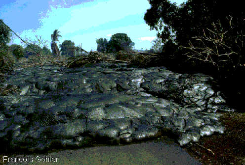 Advancing
Lava Flow
Advancing
Lava Flow
The edge of the lava flow from Kilauea crater�s eruption of April 1990 advances through the Kalapana Gardens on Hawaii Island, Hawaii. The outer surface of the lava flow cools and hardens from contact with the air, while underneath, the lava may remain molten for days.
Click
On Me to Go Back To The main Page